CHARLESTON – The Senate Redistricting Committee approved – none unanimously – proposed new district maps for the state Senate and Congress on Monday afternoon and sent them to the Senate floor, where they were read a first time during the Senate’s 7 p.m. floor session.
Before the proposed Senate map was presented, Sen. Mike Woelfel, D-Cabell, voiced concern about what may be planned. He believes, he said, the map the committee would take up and approve would only be a “pass-through” and not the bill that will be voted on in the Senate chamber.
Cabell County was formed in 1809, he said, and has never been divided. But he believes the map the full Senate will take up divides Cabell, which violates the state Constitution and the requirement for district compactness.
West Virginia is a red state, he said, and will be for a long time. “Let’s not get greedy,” he said, and partake in gerrymandering.
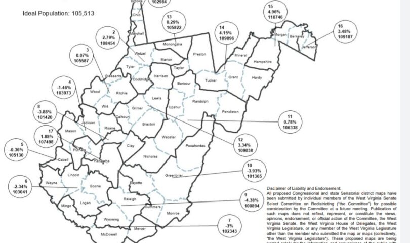
Sen. Mike Caputo, D-Marion, also objected, but for different reasons. The map the committee took up and approved, labeled Trump 8, keeps Monongalia County whole but places Marion in a district with Wetzel, Tyler, Doddridge and the western half of Marshall.
Caputo now represents the 13th District, which follows the I-79 corridor from Morgantown to Fairmont, and that area is a community of interest, he said, sharing the corridor, a health system and other commonalities.
On the other, hand, he said, Marion has little connection to the other counties in the proposed district. It would be better to link Marion and Harrison, because they sit on the I-79 corridor, co-own an airport and have other interests in common.
“I’m certainly concerned we’re going to leave here with a partisan map, and I hate that,” he said.
Committee vice chair Dave Sypolt, R-Preston, defended the map, noting it keeps all but seven counties whole. The districts are acceptable and reasonable, he said.
The committee approved the map in a voice vote; Caputo was the only audible vote against.
The Congressional map is one of the north-south variations. On this map, District 2, the southern district, is bounded along its top by Jackson, Wirt, Ritchie, Gilmer, Braxton, Webster and Pocahontas counties.
There was no discussion and it was also approved in a voice vote, with Caputo again the sole audible vote against.
Caputo said afterward that he’s open to discussion on the Congressional map on the Senate floor. But there are 18 counties that are considered economically distressed, and the proposed map includes 15 of them in the 2nd District.
“I just think we’re doing a little more of the same and expecting a different result,” he said.
He would prefer an east-west division, he said, to get a mix of struggling and successful counties in each and inspire the office holders to strive to make their entire districts strong. “I think that’s a good incentive for that.”
The Redistricting Committee had to reconvene briefly before the evening floor session to reconsider both bills and fix some technical mistakes.
Woelfel reiterated his earlier concern about the Senate map, this time calling it a Trojan horse. He decided to change his previous “yes” vote on the bill to a “no.”
The Senate meets again at 11 a.m. Tuesday. Both bills – SB 3033 for the Congressional map and HB 3034 for the Senate map – will be on second reading and subject to amendment, though Senate President Craig Blair, R-Berkeley, said SB 3034 will be moved to third reading with the right to amend.
TWEET David Beard @dbeardtdp
EMAIL dbeard@dominionpost.com
