
MORGANTOWN – The city of Morgantown hosted a spatial event on Wednesday.
It wasn’t alone.
Globally, an untold number of practitioners and beneficiaries, both public and private, took time to recognize the 25th annual celebration of GIS Day.
Stated simply, GIS, or geographic information systems, is an ever-expanding tool that uses aerial photography and software to tie data sets to location.
What once was a spreadsheet of addresses or detailed, written explanations of boundary lines can now be presented visually.
But it goes way beyond that.
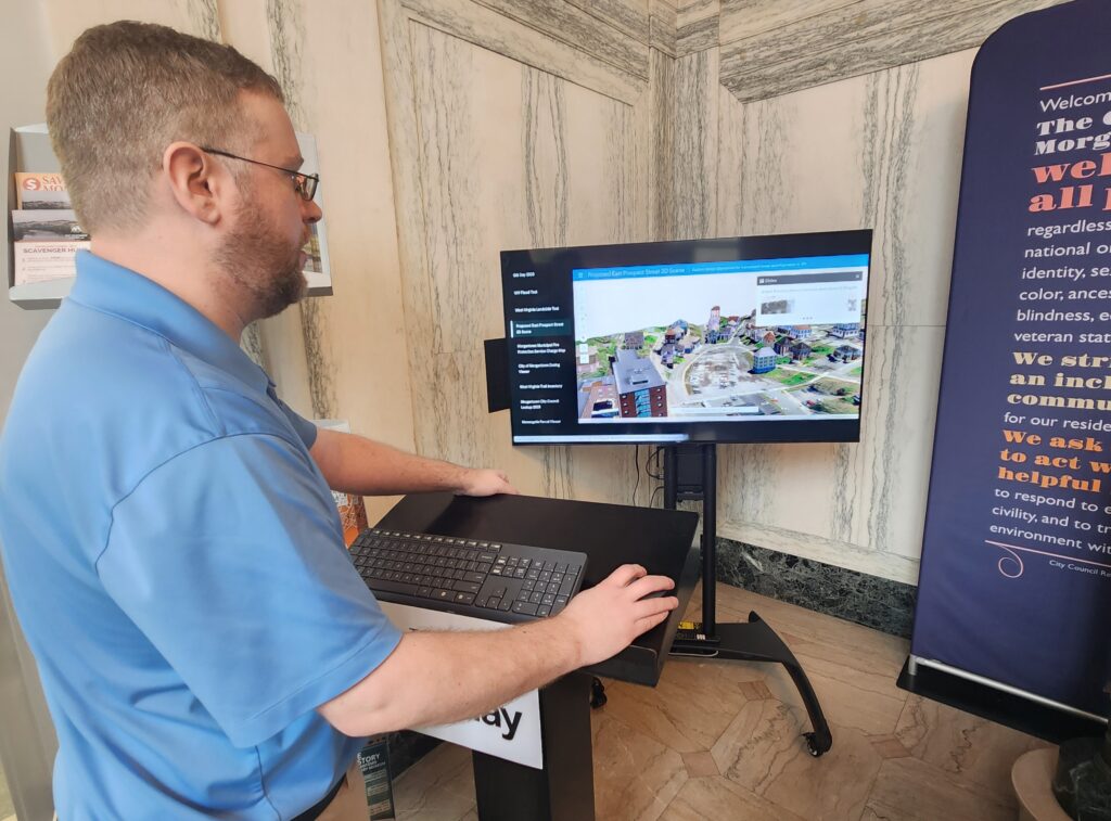
For example, it’s the backbone of the MUB Monitor, developed in collaboration with Downstream Strategies to provide real-time river flow data that can track spills and assess upstream threats to the community’s drinking water.
In another application, the city used GIS to create a tool for its Ward & Boundary Commission that allows members to instantly know how various line adjustments would impact the distribution of both population and registered voters across the city’s seven wards. Doing so in the past would have required hours spent poring over paper maps and spreadsheets.
To the unfamiliar, it’s almost impossible to fathom the potential the tool represents.
That’s where folks like Marvin Davis, Morgantown’s geospatial services manager, come in.
“Normally, I just say, ‘GIS is all.’ GIS is everything. It’s so prolific and it covers everything. It can be used in so many different fields and so many different industries in so many ways because it all goes back to the fact that it’s an information system. It’s all about information,” he said. “We all need to be informed, and the power of GIS is that it brings location into it. Location has its own importance to data, and not a lot of people see that until they actually have it in front of them.”
Outside of work already underway at WVU, public access to GIS first came to Monongalia County at the urging of former county Floodplain and GIS Coordinator Mike Paugh, who approached the Monongalia County Commission in 2013 with the backing of recently-elected Assessor Mark Musick.
“I always joked that when I first came into office that I couldn’t spell GIS,” Musick said. “But I knew what was possible just by doing some homework and looking at different things and seeing the benefits it could have for the office, the county and the taxpayers. I remember going to Preston County and looking at their site, and I was like, ‘We’ve got to have it.’”
In 2015, the commission put up $38,500 for the software ($20,000) and first set of aerial images ($18,500), to which layers representing MECCA 911 addressing, parcel mapping, planning district boundaries and floodplain information were added.
In June 2016, all that information became accessible to anyone with a web browser through the county parcel viewer website, available at assessor.org.
Since then, Monongalia County has had aerial photography flown annually, funded out of the assessor’s budget. Subsequently, the county has moved the county’s GIS coordinator into the assessor’s office.
“It’s just such a useful tool,” Musick said, explaining that GIS hasn’t really lessened the amount of work his office does, but has revolutionized the way it’s done.
“I get a lot of comments from Realtors. They use it constantly – lawyers, developers, the general public. It’s a tool for our office, but we want everyone to benefit from it. Sure, there’s a cost to it, but you have to look at what you’re getting back. Some counties pay a lot of money for it, but they only update it every three or four years. With the development we have here, just imagine if we did that every three years, the gap you’re going to have when you’re trying to look at things.”
In 2021, the city, county and Morgantown Utility Board came together to form the Monongalia Morgantown Area Geospatial Consortium (MMAGIC), to better facilitate the sharing of costs and data. Through MMAGIC, other entities like the city of Westover and the Morgantown Monongalia Metropolitan Planning Organization have begun budgeting to support the efforts.
Today, the county’s parcel viewer provides overlays including Morgantown zoning and overlay districts, among a number of others.
Davis said all that data was recently folded into the online permitting and licensing portal the city rolled out last year.
“When you put your street address in for that permit or license, it creates a case, and on the back end it’s already pulling from all the data sets that city, county or state maintains and giving that information to the appropriate city staff. What zoning is it in? What ward is it in? Is it in a flood zone?” Davis said. “On the other side of that coin, we’re building data sets. Things like when permits have been issued and completed, and where they have been issued. We can look at active businesses, active rentals, active vacant structures. That gives us a working map that’s really maintaining itself.”
The next step, he said, will be the creation of a city-specific, public-facing viewer to make that information available and searchable.
“That way, if someone sees a lot of work going on, or something like that, they could look and see that, okay, a permit has been issued. Then they don’t have to call the city and yell at somebody thinking unpermitted work is happening,” Davis said.
Morgantown’s GIS Day open house was held in conjunction with the WVU Department of Geology and Geography and the West Virginia Association of Geospatial Professionals.
